A few months ago, I was contacted by the developers of Gaia GPS. (https://www.gaiagps.com). They offered a 3 month subscription for me to download the app and use it everywhere I hunt. I snapped it up and used it (hunted with it) in South Dakota, Nebraska, New Mexico, and Arizona. In addition, I tested it (called up areas I hunt in these states from the comfort of my living room) in Michigan, Texas, Oregon, Georgia, Wisconsin, and Florida.
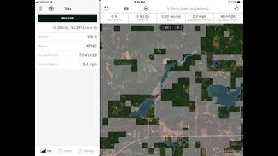
The screen-shot above shows the iPad picture of the app. I
use it on an iPhone 7S while hunting. When I get a cell signal, or WiFi, all
the data is uploaded across my devices.
Across the top, the first logo shows (when selected) the
accuracy of the gps signal, then the ‘take a picture’ icon, expand the screen,
layers, more menus, search, find me. The
boxes above the main screen can be personalized to whatever data you want to
see. Below that is the compass heading,
selectable between true and magnetic.
Of course, many places I hunt have no cell signal. In fact, even if there is a cell signal, I
will turn my phone to the “airplane” mode to 1) stop all battery killing
background operations, and 2) keep the gps running and tracking. If you need
the maps while hunting, you can use the available cell system, or download the
map ahead of time (like the last spot you know you’ll get service) and use
airplane mode and a stored map you create.
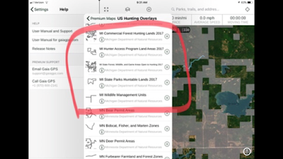
The “layers” icon is the real bonus! Here is where you’ll find all the cool
maps.
Once you record a track, you’ll be asked to name it and save
it. You can make notes (e.g., shot 4 limits today over Biscuit-eater, or I’ll
never hunt with this guy again!) Then
you can view it on the website and your other devices.
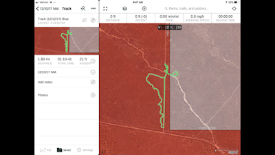
Here’s a screenshot of a saved track from December 12,
2017. This is my track (that’s where the
phone is), but, in the title, you can see I was running my puppy, Blue. You can plainly see the roads and that I was
on BLM land most of the time and on State Trust Land a portion of the cast. Total
distance, time, and climb or descent is also saved. I don’t have it in my
notes, but this would be New Mexico. On
the left side of the track is where you’d see notes and any photos I took while
on the cast.
I’m not going to hit every detail. I used it on the ground
and it worked every time. I’ve only covered 40% of the capabilities.
I could go on and on, but here is the bottom line: I like it
better than other apps out there. I just bought another year of Premium
Membership ($40). To me this app is the iPhone of the industry- it’s made to
work and flow intuitively. If you can’t figure something out, it’s because
you’re thinking too hard. It gives me all the layers I need, and plenty of
capability. And, it’s $60 cheaper than
other apps! I know I’ve been a strong
proponent of gps apps. This one is in front now and I have it as BUY. Don’t
go west without it.
To purchase the premium app with all the maps for hunting over the entire US at 20% off,
Click HERE or click the GAIAGPS logo on the BLOG Home Page.


